Mount Stuart Solo Hike, Labor Day 2019

Mountain peaks are one of those things I have always felt amazed at. They stand up high with wisdom the rest of the world just doesn’t have. But it’s only been in recent years that mountain peaks have started calling my name. Or maybe I have just started to listen. They are beckoning me, challenging me to climb, plant my feet on top and capture the views only that mountain knows.
Labor Day 2019: Mount Stuart Solo Hike
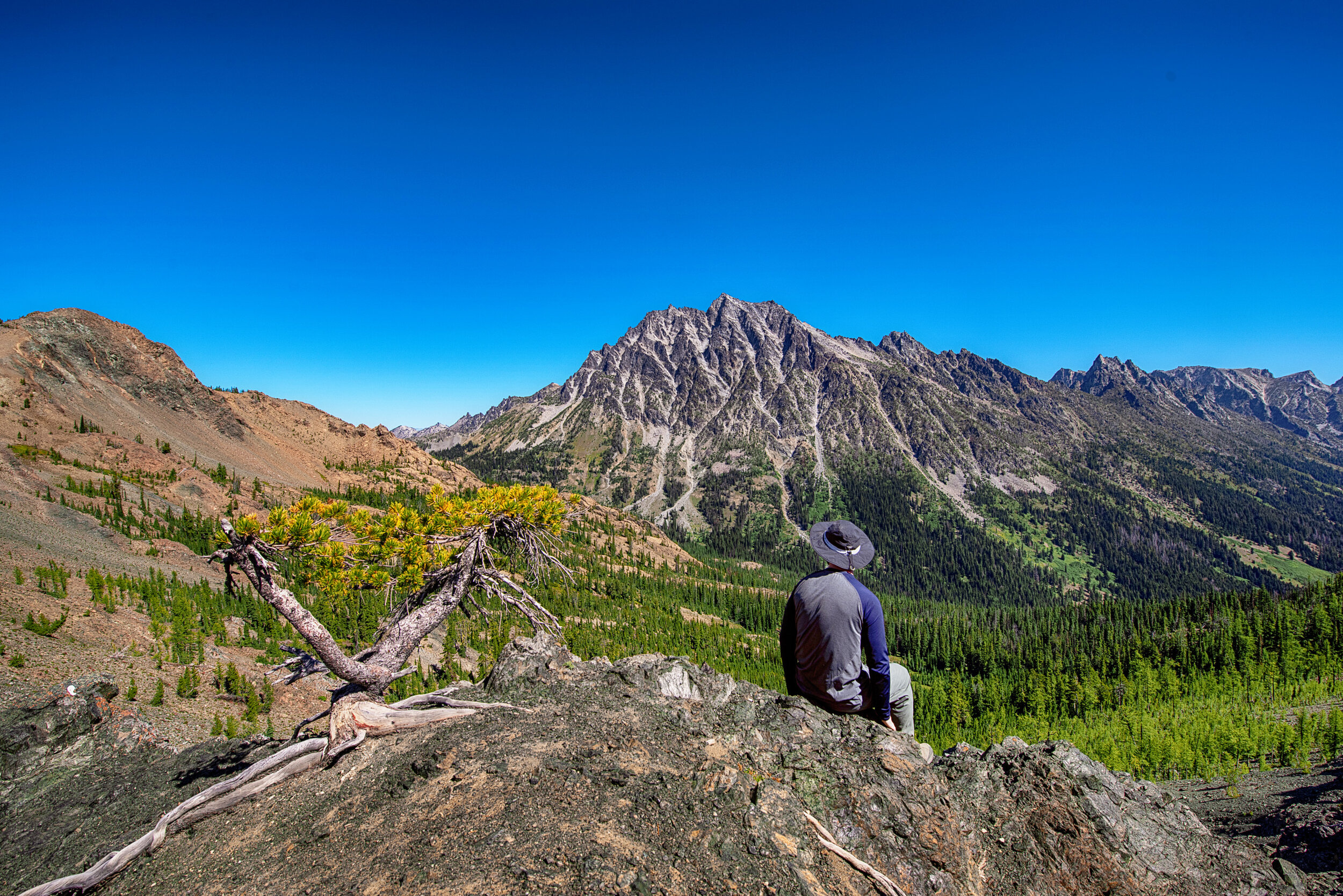
On the top of Longs Pass. Some days you have to climb another mountain just to get to your mountain.
"Just 12.6 miles total in and out", I told myself as I thought about longer day hikes and multi-day hikes I've done. This was different though. Most all of the way up Stuart is scrambling on rocks and sand in a couloir. Also, to get to the start of Stuart, I was going to start at Esmeralda Trailhead, climb 2000’ up to Longs Pass, and 1550’ down to Ingalls Creek. Then it’s 4600’ elevation climb up to the summit of Stuart.
I should mention that I decided on hiking Stuart the night before, around 10pm. It was a busy weekend, and although I was planning on doing a Mon/Tue hike, I hadn’t yet decided where I was going. I was just feeling like doing a hike that was a whole other challenge level than what I had done. At 10pm I sat in a sofa chair in the living room to plan a hike. I looked up on the wall to a 4 foot panoramic photo I had taken in 2008 of the Enchantments, with Mount Stuart in the center. It just hit me: I’m going to hike Mount Stuart.

My first landscape photo assignment, Stuart Range, April 2008
This panoramic image I made in 2008 was the first non-portrait photo assignment I was given. After photographing the Stuart Range for display in a new lobby of Ellensburg’s Foursquare Church, I have always felt a sense of connection to the mountain every time I drive down I-90 and got a view of it.

More photos from April 16th, 2008. Look at the push-pull lens I was rockin.
So that was it. I had my mind set to hike Mt Stuart, no matter how unprepared I was. I just needed to gather my gear and pack it up, prepare some meals, and plan out the hike/trail specifics. I wasn’t finding much help on the app I normally use, AllTrails, but I found a trail on a $4 offline map app I’ve had for years, Guru Maps. And I read a review on Washington Trails Association website that it was currently possible to get up to the summit without stepping a foot in snow. There was no need for an ice axe or crampons. What I would eventually realize is how much sand and loose rocks there are to climb up and how elusive that “trail” (AKA Cascadian Couloir) can be going up Stuart.
I hit the road at 6:30am and was at Esmeralda Trailhead parking lot by 9:40am. I still had to arrange stuff into my pack and then started up the trail at 10:30am. I made it to the top of the first ascent, Longs Pass, at 11:50am.

On the way up to Longs Pass. Legs getting warmed up.
Lunch at Ingalls Creek and 3 Liters load up on water
After my Ingalls creek stop, and taking Ingalls Creek Trail #1215 to the right, there are several nice camp spots. This is where most people set up camp to hike Stuart as a day hike. I remember seeing at least 6 tents setup as I passed by, but I really didn’t pay much attention. I had no interest in camping anywhere other than my destination. The point of staying the night for me was to take photos from the top at dusk and at dawn. Sleep was just something necessary I had to fit in between the two.
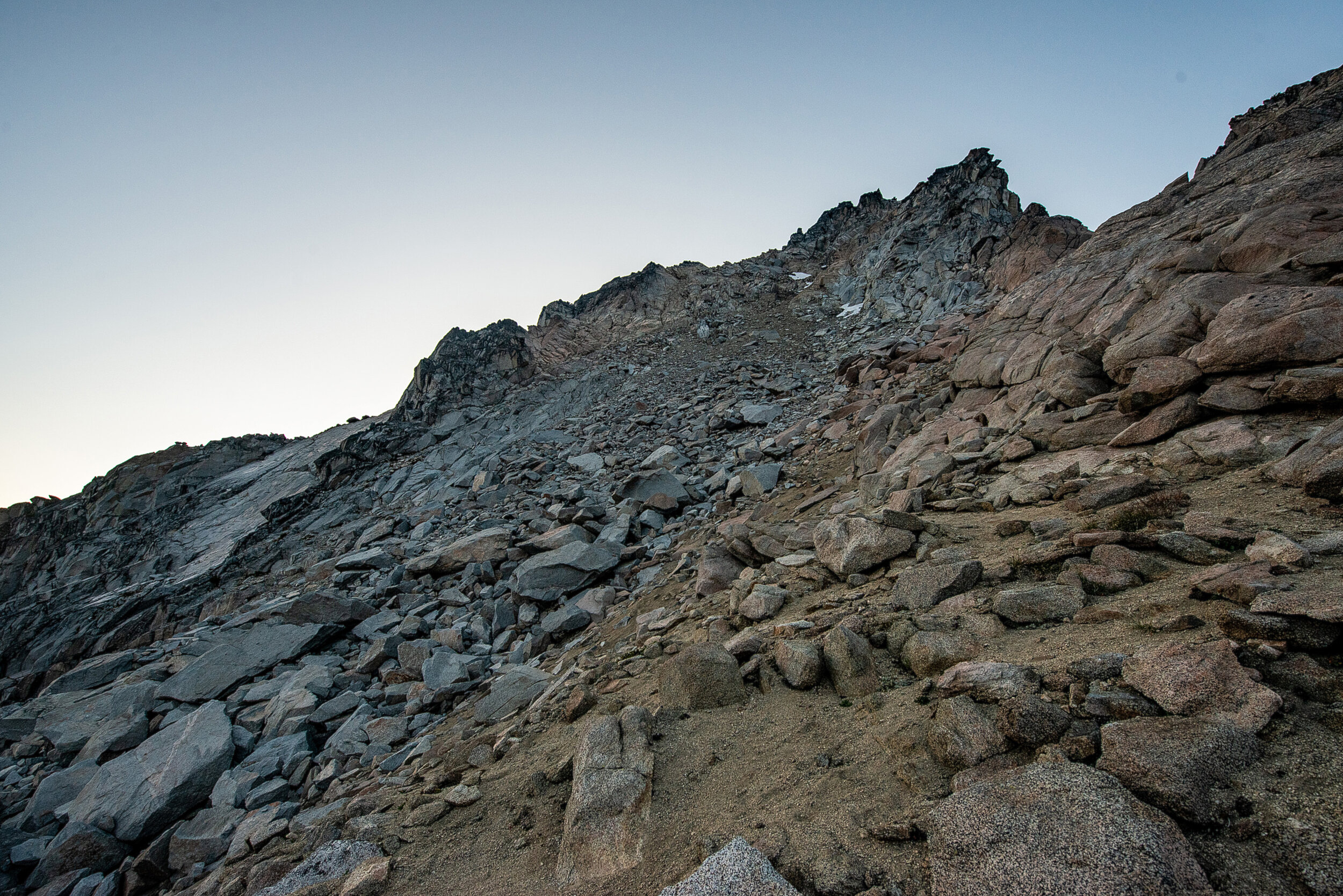
Looking up towards a false peak on terrain where I wasn't able to find a definable trail

By the time I reached the ridge from the Cascadian Couloir at about 8600’ elevation, the sun was setting. It was in that moment that I found a spot someone had cleared rocks and built a wind barricade for a small tent. I decided it was best to drop my pack here and get to taking photos ASAP.


Looking down at what was left of the Ice Cliff Glacier
While taking photos I slowly scrambled up making roughly another 250’ elevation gain. But being that it was now dark, I was thinking about getting my tent setup and eating some food. On the way back down to set up the tent I took this shot of the moon.

I haven’t done much astrophotography, but I do enjoy trying it. Since I plan on being in the mountains more, I have the feeling that I will be doing more photos of the night sky. It was really awesome being able to see the stars and Milky Way so clearly (after I realized I still had my sunglasses on, that is lol).
It was around 9pm and dark when I met 2 other people, the only other people I saw on Mount Stuart during my hike. I was taking pictures of the stars and saw the light from 2 headlamps coming down from the summit. They came near my tent and we chatted a bit. They had come from New York and had started on the north side of Stuart at 3am and were now heading out to the same parking lot I had just spent 7 hours to hike in from. Now that’s a workout!

At 10pm I started thinking about eating dinner. I decided I needed to save my remaining water to drink in the morning and I skipped boiling water and ate the cold food I had brought. I was not worried about food, more about water supply might something go wrong on the way down.
Even despite the heavy winds pounding on the walls of my tent all night long, I was tired enough to be able to get some sleep (PM Aspirin probably helped too). I set my alarm for 5:29am and was out taking pictures by 5:37am.
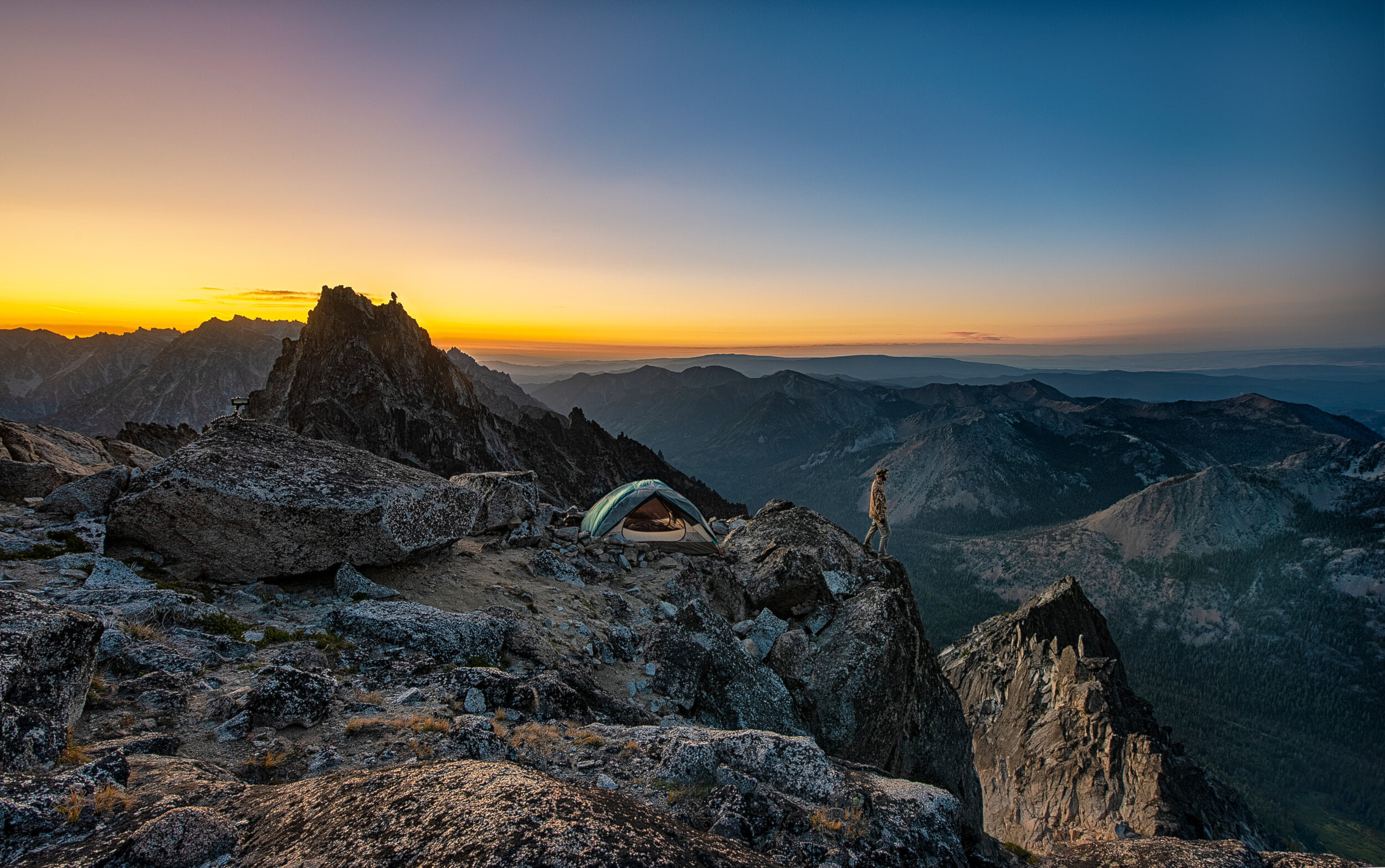
Looking out from my campsite at sunrise


I wrapped up my morning photos by 7:30am, packed up, and headed back down. The hike down is a story probably best saved for another time. I’ll just say, my external battery pack lost all of its charge overnight in the cold and I had to do my whole hike out without my phone or any other mapping. Somehow I started down the couloir to the left (east) instead of going back down the Cascadian which I had planned on. The way I was descending became unsafe and I ended up scaling down part of the mountain section between the couloirs. I can’t tell you how excited I was that I had made it back in one piece with only a single minor cut on my leg!
EDIT: It’s been over a year since this trip and I often find myself thinking about how this experience was a huge turning point for me. I had known hiking, I knew camping, and I knew backpacking. But what I realized was that I didn’t know mountaineering and I had the desire to learn.
If you have any interest in collaborating on a hike or outdoor photography, I’m all ears! >> ross@rossjames.net